
Compass, Map and Spyglass

Let's just take things one step at a time. For starters, you need to find a compass, map and spyglass to navigate the terrain. Hurry up! The nature is very unpredictable and if you don’t pick up those things in time, they will be absorbed by the coastal sand or washed away into the sea.
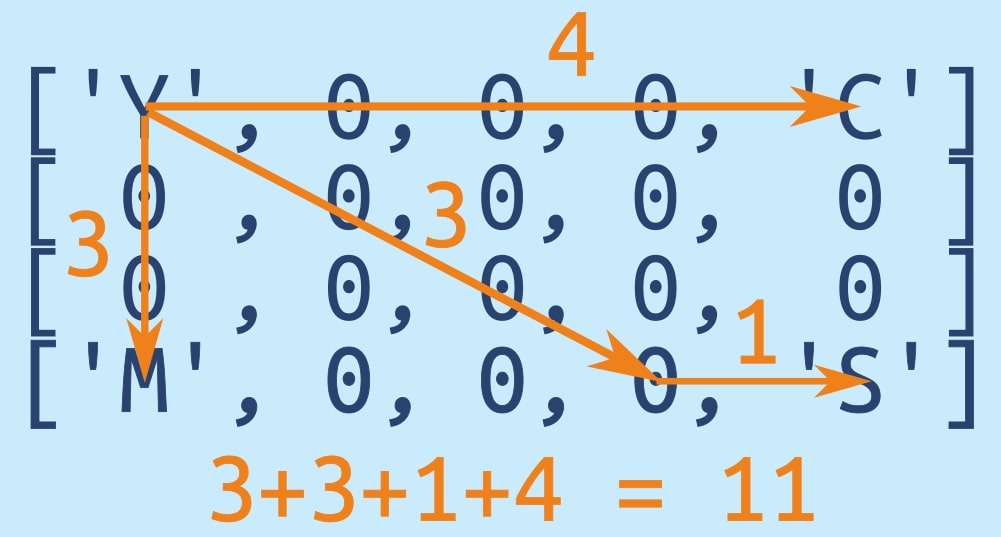
Your task is to count the sum of the number of steps required to pick up all 3 items - ('C' - compass), ('M' - map), ('S' - spyglass) from your starting position. So the result will be the sum of distance from Y to C, from Y to M and from Y to S (not Y-C-M-S).
Note that you can walk in 8 directions - left, right, up, down and sideways (on the diagonal in any direction). Your starting position is 'Y'.
Input: Array with the objects placements.
Output: The length of the path.
Example:
navigation([['Y', 0, 0, 0, 'C'],
            [ 0,  0, 0, 0,  0],
            [ 0,  0, 0, 0,  0],
            ['M', 0, 0, 0, 'S']]) == 11 #4 steps from Y to C, 4 from Y to S and 3 from Y to M
How it is used: For the finding the length of the path.
Precondition
:
3x2 <= array size <= 10x10
CheckiO Extensions allow you to use local files to solve missions. More info in a blog post.
In order to install CheckiO client you'll need installed Python (version at least 3.8)
Install CheckiO Client first:
pip3 install checkio_client
Configure your tool
checkio --domain=py config --key=
Sync solutions into your local folder
checkio sync
(in beta testing) Launch local server so your browser can use it and sync solution between local file end extension on the fly. (doesn't work for safari)
checkio serv -d
Alternatevly, you can install Chrome extension or FF addon
checkio install-plugin
checkio install-plugin --ff
checkio install-plugin --chromium
Read more here about other functionality that the checkio client provides. Feel free to submit an issue in case of any difficulties.
Welcome to Pair Programming! Engage in real-time collaboration on coding projects by starting a session and sharing the provided unique URL with friends or colleagues. This feature is perfect for joint project development, debugging, or learning new skills together. Simply click 'Start Session' to begin your collaborative coding journey!
You are trying to join a pair programming session that has not started yet.
Please wait for the session creator to join.
It looks like the creator of the pair programming session closed the editor window.
It might happen accidentally, so that you can wait for reconnection.


